|
| RockWorks - Cross Sections |
 |
| In addition to displaying your borehole data as logs and log sections, RockWorks
2004 also allows you to create cross sections of interpolated (modeled) data:
lithology distribution, stratigraphic layers, quantitative data distribution
(geochemistry, geophysics, geotechnical), fracture proximities and aquifer
surfaces.Both single-panel profiles and multi-panel sections are available. Panel
endpoints can be defined interactively in a map window, or they can be read from an
endpoint list.All include automatic section location maps, detailed coordinate
annotation, and logs can be appended automatically.Use ReportWorks to create
stunning page layouts with maps, legends, scale bars, and more. |
| |
| In addition to displaying your borehole data as logs and log sections, RockWorks2006 also allows
you to create cross sections of interpolated (modeled) data: lithology distribution, stratigraphic
layers, quantitative data distribution (geochemistry, geophysics, geotechnical), fracture
proximitiesNEW, aquifer surfaces. |
| |
| Both single-panel profiles and multi-panel
sections are available. Panel endpoints can be defined interactively in a map window, or they can
be read from an endpoint list. |
| |
| All include automatic section location maps,
detailed coordinate annotation, and logs can be appended automatically. |
| |
| Use ReportWorks to create stunning page
layouts with maps, legends, scale bars, and more. |
| |
| Lithology Sections |
Display interpolated lithology as profiles and multi-panel sections. These are vertical slices of
a solid lithology model.

Vertical 2D profile of lithology data
|
| |
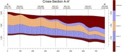
| Stratigraphy Sections |
| Display stratigraphic layers as
profiles and as multi-panel sections. Both "straight" sections with simple linear correlations, and
modeled sections, based on grid surfaces, are available. |

2D stratigraphic profile |
| |
| Quantitative Sections |
| Display your interpolated geochemistry, geophysical, geotechnical or other quantitative data as single or multi-panel sections. The panels are vertical slices of a solid model. Include line and/or color-filled contours on the panels. |

Soil plasticity profile with superimposed logs showing quantitative data as histograms |
| |
| Fracture Sections |
| Display proximity to fractures as single and multi-panel cross sections. Include line and/or color-filled contours on the panels. |

Vertical profile from fracture data model |
| |
| Aquifer Sections |
| Aquifer top and base surfaces can be displayed in profile or section diagrams. Overlay strip logs for a stunning look. |

Aquifer profile with stratigraphy logs |
| |
|
|
|
|
| Helping Communities |
|
Project Review
Ecoseal reviewed the ACIAR Project on Sustainable Agriculture in Saline Environments through Serial Biological Concentration, which was carried out in Pakistan and Australia. |
|
| Read More |
|
Seawater Intrusion Model for the Island of Kayts, Sri Lanka
Assessing sustainable water supply options for Kayts to limit the impact of saline groundwater upconing and saltwater intrusion along the northwest coast of Sri Lanka. |
| Read More |
|
Groundwater Management Model for the Lower Murray, Australia
The aim of this project was to develop a groundwater management model which was used by natural resource managers and the community to better manage the groundwater resources of the Lower Murray. This region has been designated as a potential high-risk aquifer system.
|
| Read More |
|