|
| RockWorks - in the mining industry |
 |
| RockWorks is well suited for use with coal, industrial mineral (aggregates, limestone), and other stratabound economic deposits, in both the exploration and production phases. |
| |
| RockWorks features applicable to the mining industry |
- Prior to drilling, use RockWorks2006 for creating surface geochem contour maps, 2D elevation contour maps and 3D terrain models.
|
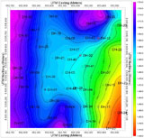
Contour map of surface geochem assay values |
|
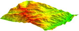
Topography terrain model based on DEM data |
|
- The surveying and land grid utilities in RockWorks2006 can help with planning drilling and lease boundary issues.
|
Lease map superimposed on Jeffersonian land grid map |
|
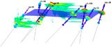
- After drilling, process and visualize your drillhole stratigraphy or lithology data by creating:
|
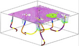
Deviated drillholes and overlying surface open pit workings |
|
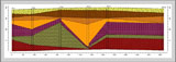
|
Stratigraphic profile with superimposed logs showing geophysical exploration gamma/resistivity data |
|
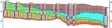
- correlated cross-sections
|
Hole to hole cross section |
|
- fence diagrams
- stratigraphic block models
|
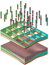
Solid Model Volumetrics |
|
- Finally, there are many options for your assay data:
- create 3D solid geochem models with numerous viewing options (isosurfaces, profiles, fences)
|
Geochemistry model shown as "ore blobs", based on ore assay data. Angled drillholes with assay values also shown, as is planar elevation level for reference. |
|

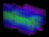
Voxel model depicting BTU values within a coal seam |
|
- a feature-rich reserve estimation menu, which includes grade range, overburden, stripping ratio, interbed and thickness filters
|
A wireframe model of Pb reserves in a Mississippi type Pb-Zn deposit- the reserve model was constrained by lease boundaries and overburden filters. |
|
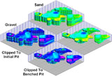
Clipping sand and gravel ore models based on a benched pit design |
|
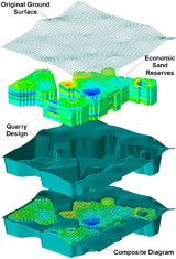
Extracting a solid model of sand ore reserves from host rock for the purpose of quarry design |
|
- You can even create simple mine working and pit models!
|
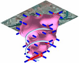
Kimberlite composite- draped airphoto, mine workings, and isosurface depicting ore zone |
| |
|


