|
| Didger - Easy Image Georeferencing |
 |
| |
Didger's fast and easy georeferencing process makes it possible to rapidly convert un-referenced images and scanned paper documents to real world coordinate systems (e.g., UTM, State Plane, Latitude/Longitude) for use in Didger or other GIS programs.
Use a set of control points or point locations in your existing project to georeference a new image. Simply pick three or more points on the image, assign coordinates to those points, assign a projection and datum if applicable, and import! If you don't know the coordinates of any points on the image but you know where in the project the image is supposed to be, you can simply choose points on the image and tie them to the corresponding locations in your existing project! It's that simple! |
| |
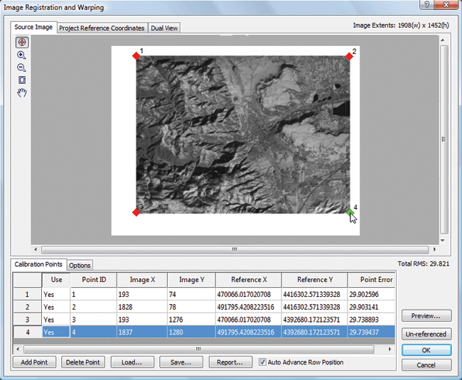
Registering an image has never been easier! Simply enter the calibration points, click on the image and it is ready to load into your project! |
| |
Didger also gives you more options than ever to make sure the georeferencing of your image is of the highest quality! You can choose one of to give you the most precise georereferencing possible. Didger automatically calculates and reports the root-mean-square (RMS) error value for immediate evaluation of the georeferencing accuracy. When the georeferenced image is loaded into your project, the image is warped to eliminate any distortion, so that the georeferencing matches the calibration exactly! There's no better way to georeference your images!
Once an image is georeferenced and loaded into Didger, you can overlay it with other spatial data, digitize information from it, tile it with other georeferenced images, or export it to a georeferenced image format for use in other programs. Didger imports and exports industry standard GeoTIFF, Blue Marble RSF, Golden Software GSR, ESRI PRJ, and ESRI World (TFW, JGW) referencing files. |
| |
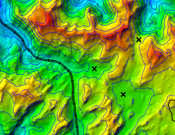
A georeferenced satellite image was overlaid with a data file of sample locations and vector files of roads and contours.
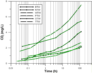
Didger is not just for maps! Digitize any plotted information, such as graphs or well logs, from a digitzing tablet or scanned image. For example, the six curves in the above scanned graph were digitized in green, ready for export! |
| |
|
|
|
|
| Helping Communities |
|
Project Review
Ecoseal reviewed the ACIAR Project on Sustainable Agriculture in Saline Environments through Serial Biological Concentration, which was carried out in Pakistan and Australia. |
|
| Read More |
|
Seawater Intrusion Model for the Island of Kayts, Sri Lanka
Assessing sustainable water supply options for Kayts to limit the impact of saline groundwater upconing and saltwater intrusion along the northwest coast of Sri Lanka. |
| Read More |
|
Groundwater Management Model for the Lower Murray, Australia
The aim of this project was to develop a groundwater management model which was used by natural resource managers and the community to better manage the groundwater resources of the Lower Murray. This region has been designated as a potential high-risk aquifer system.
|
| Read More |
|


