|
| Didger - Map Projections, Datums and Coordinate Conversion Options |
 |
| |
Didger makes it easy to assign or change the projection and/or datum of your data, vector, or image files from one coordinate system to another. For example, in a few simple steps you can convert latitude/longitude data to State Plane data, State Plane data to UTM data, or convert your data from NAD27 to NAD83. You can import multiple data sets into your current Didger project and Didger converts the projection of the files automatically during import to match that of the current project; or, you can convert the projection of data sets individually, save them in the new projection, and use them in other applications. It has never been this easy to seamlessly combine all your information.
Didger supports 29 popular projections and allows you to specify settings for each projection appropriate to your data set. Didger's datum dictionary contains the definitions of over 250 datums used around the world. You can even create your own custom datum and add it to the datum list! When defining a custom datum, you can select one of 56 ellipsoid definitions or define your own ellipsoid, and choose between Molodensky and Bursa Wolfe datum transformation methods. Save projection parameters and custom datum settings to a file and load it the next time you want to use the same settings! This saves you time so you don't have to keep manually entering the same settings for each project.
In addition to projection and datum transformations, Didger can also convert coordinates of vector and data files by utilizing either a math or georeference operation. If you just want to shift your data coordinates by 50 meters, simply use the math operation to add 50 meters to all the coordinates in your project. You can add, subtract, multiple, and divide your X and/or Y coordinates using any constant value. Alternatively, if you know real world coordinates of specific points in your vector files, you can use the advanced georeferencing operation. Simply click on the source location, enter the destination coordinates, and Didger's georeferencing methods will convert the current project into the new coordinate system. It's that easy! |
| |
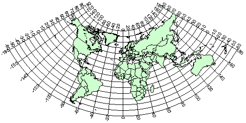
Create stunning world maps in a variety of projections to convey your information easily. The graphic above uses the Equidistant Conic projection. |
| |
|
|
|
|
| Helping Communities |
|
Project Review
Ecoseal reviewed the ACIAR Project on Sustainable Agriculture in Saline Environments through Serial Biological Concentration, which was carried out in Pakistan and Australia. |
|
| Read More |
|
Seawater Intrusion Model for the Island of Kayts, Sri Lanka
Assessing sustainable water supply options for Kayts to limit the impact of saline groundwater upconing and saltwater intrusion along the northwest coast of Sri Lanka. |
| Read More |
|
Groundwater Management Model for the Lower Murray, Australia
The aim of this project was to develop a groundwater management model which was used by natural resource managers and the community to better manage the groundwater resources of the Lower Murray. This region has been designated as a potential high-risk aquifer system.
|
| Read More |
|


