|
| Didger - Surfer Compatible |
 |
| |
| Surfer Compatible Now it is easy to see your maps the way you want them! Automatically digitize contour or other 3D data in Didger and send them directly into Surfer with a click of a button to change contour properties, overlay with 3D terrain surfaces, DEM files, or other 3D imagery. Didger also makes it easy to directly convert the projection Surfer GRD or DEM files, so you can have all your maps in the same coordinate system in Surfer! |
| |
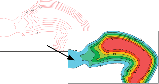
Digitize your information, recording the Z value and automatically create colorful contour, image, or shaded relief maps in Surfer! |
| |
|
|
|
|
| Helping Communities |
|
Project Review
Ecoseal reviewed the ACIAR Project on Sustainable Agriculture in Saline Environments through Serial Biological Concentration, which was carried out in Pakistan and Australia. |
|
| Read More |
|
Seawater Intrusion Model for the Island of Kayts, Sri Lanka
Assessing sustainable water supply options for Kayts to limit the impact of saline groundwater upconing and saltwater intrusion along the northwest coast of Sri Lanka. |
| Read More |
|
Groundwater Management Model for the Lower Murray, Australia
The aim of this project was to develop a groundwater management model which was used by natural resource managers and the community to better manage the groundwater resources of the Lower Murray. This region has been designated as a potential high-risk aquifer system.
|
| Read More |
|


