|
| Didger - Uses for Didger |
 |
| |
Start processing your data quickly and accurately with Didger. Some applications for Didger include:
- digitizing points, polylines, and polygons, such as oil and gas wells, monitoring wells, wireline logs, graphs, contour lines, aerial photographs, satellite images, seismic lines, roads, property boundaries, buildings, sample locations, faults, rock formations, vegetation boundaries, and animal habitats
- calculating areas of polygons, such as watershed or lake areas
- calculating lengths of polylines, such as shorelines, roads, streams, or migratory routes
- georeferencing and/or mosaicking aerial photos or scanned images
- converting the projection of scanned images, vector files, data files, or Surfer GRD or DEM files
- overlaying vector, data, and image files to create a complete map
- and much more!
|
| |
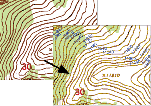
Didger makes it easy to quickly extract the data you need from images. Import an image, such as a USGS Digital Raster Graphic, and Didger can automatically pick out and digitize the contour lines in seconds (digitized in yellow above). Assign elevations to the contours and with just a few clicks import the contour data directly into Surfer as a colorful and customizable contour map, ready to overlay or combine with other data.
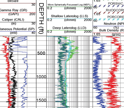
Digitize any map, graph, aerial photo, site map, or printed image regardless of size using any Wintab compatible tablet, or scan it in and digitize it onscreen! For example, import and calibrate a scanned image of a well log and digitize the log information, including any wrapped portions of the log! Easily export the digitized data to an LAS file.
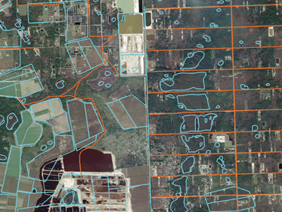
Mosaic multiple large USGS Digital Ortho Quarter Quads (DOQQs) and overlay them with other imported information, such as hydrography (blue) and road (orange) data. Reproject files on import so all your data is in one cohesive coordinate system.
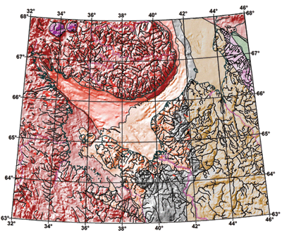
Georeference images in Didger and digitize information directly on the image. Change the projection of the entire project and add graticule lines to ensure your data is presented at its best. Digitized data can be exported to all industry standard vector files such as SHP, MIF and DXF. |
| |
|
|
|
|
| Helping Communities |
|
Project Review
Ecoseal reviewed the ACIAR Project on Sustainable Agriculture in Saline Environments through Serial Biological Concentration, which was carried out in Pakistan and Australia. |
|
| Read More |
|
Seawater Intrusion Model for the Island of Kayts, Sri Lanka
Assessing sustainable water supply options for Kayts to limit the impact of saline groundwater upconing and saltwater intrusion along the northwest coast of Sri Lanka. |
| Read More |
|
Groundwater Management Model for the Lower Murray, Australia
The aim of this project was to develop a groundwater management model which was used by natural resource managers and the community to better manage the groundwater resources of the Lower Murray. This region has been designated as a potential high-risk aquifer system.
|
| Read More |
|


