|
| Didger - Vector Based Maps and Data Files |
 |
| |
With Didger you can import a variety of vector based maps and data files in many formats. Create large coverages easily by importing several vector or data files into one project. The files will align according to their coordinate systems. Digitize new features onto an existing vector plot from your digitizing tablet and map, or digitize onscreen. Change line styles, object IDs, and add labels to objects with ease. Even import different files onto separate layers!
If the files are projected and contain different projection information, they will be converted to the projection of the first imported file using a datum transformation. You can also convert vector or data files from one projection to another. |
| |
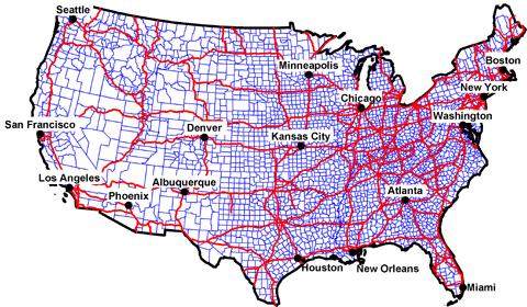
This graphic shows three vector files and a data file imported into Didger in the Lambert Azimuthal Equal Area projection.! |
| |
|
|
|
|
| Helping Communities |
|
Project Review
Ecoseal reviewed the ACIAR Project on Sustainable Agriculture in Saline Environments through Serial Biological Concentration, which was carried out in Pakistan and Australia. |
|
| Read More |
|
Seawater Intrusion Model for the Island of Kayts, Sri Lanka
Assessing sustainable water supply options for Kayts to limit the impact of saline groundwater upconing and saltwater intrusion along the northwest coast of Sri Lanka. |
| Read More |
|
Groundwater Management Model for the Lower Murray, Australia
The aim of this project was to develop a groundwater management model which was used by natural resource managers and the community to better manage the groundwater resources of the Lower Murray. This region has been designated as a potential high-risk aquifer system.
|
| Read More |
|


