|
| Didger - Working with Images |
 |
| |
Images are powerful visualization tools, whether they are aerial photographs, scanned geologic maps, or company logos. Didger makes working with images simple and uncomplicated.
TerraServer images! Didger 4 includes the astounding ability to link directly to the USGS TerraServer database and download satellite imagery and topographic maps free of charge! Simply select the area of interest and the images are imported into your project and automatically georeferenced!
Tremendous flexibility when importing images! Whether you import one image, or mosaic multiple images together,Didger makes it easy for you. You can import georeferenced images that are imported automatically in the correct locations, you can import images which you can georeference upon import, or you can import images which you can drag and drop anywhere in your project. For example, you can import georeferenced TerraServer images of your project area directly into Didger, combine it with some new aerial photography that you georeferenced in Didger, and then add a company logo or small reference map and place it in the corner of the project.
Clip your images! Didger offers more options than ever to clip your images to the extents you need. Import multiple adjacent USGS DRG files and automatically clip off the collars to seamlessly view the entire map. You can also simply draw a polygon and clip your image(s) to that polygon. If you make a mistake, or want to see the entire image again, you can always remove the clipping. If your image is very large and you only need a small portion of it, you can permanently crop the image. |
| |
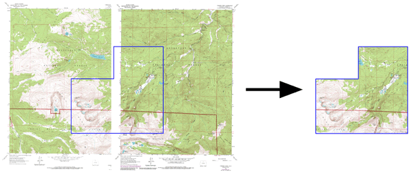
Two adjacent USGS DRG files were imported into Didger and a polygon outlining the area of interest was digitized on top in blue (left). The collars were clipped from the DRGs and the images were clipped again to the polygon (right). |
| |
Powerful Image Processing! There are many useful image-editing tools available in Didger to use on an imported image. You can select up to 256 colors to be transparent in an image so you can view objects behind the image, change a selected color to any other selected color, convert the color depth of an image, change the number of colors in an image, sharpen images to emphasize details and aid in restoring them to a more enhanced state, "blur" the image so that major details are seen more easily and background noise and other anomalies are removed, filter the image to help accentuate spatial details, and adjust the contrast, brightness, and saturation of the image to fine tune the visibility of the image. You can also convert an image to grayscale or black and white, which is useful when the file size is very large because these color modes reduce the memory overhead and allows the program to process information more quickly.
Large image handling and MrSID compatibility! Improved technology is making large image files increasingly common. Didger 4 contains the most sophisticated and advanced image handling routines to import and export large image. Didger also allows direct import of MrSID files, making it even easier to work with large images! |
| |
Import high resolution MrSID files seamlessly into Didger! In this example, four 1-meter resolution MrSID files were imported. Utilization of the image includes identifying areas obscured by trees or vegetation that require additional field survey, digitizing the centerlines of roads, property boundaries, etc., and exporting to a DXF or geo-referenced image file to be used by other software for flight planning and target placement.

Create and export large image coverages easily!
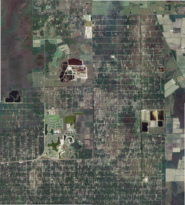
In this example, seventeen USGS Digital Ortho Quarter Quads (DOQQs) were overlaid, ready to be digitized or overlaid with other vector data. |
| |
|
|
|
|
| Helping Communities |
|
Project Review
Ecoseal reviewed the ACIAR Project on Sustainable Agriculture in Saline Environments through Serial Biological Concentration, which was carried out in Pakistan and Australia. |
|
| Read More |
|
Seawater Intrusion Model for the Island of Kayts, Sri Lanka
Assessing sustainable water supply options for Kayts to limit the impact of saline groundwater upconing and saltwater intrusion along the northwest coast of Sri Lanka. |
| Read More |
|
Groundwater Management Model for the Lower Murray, Australia
The aim of this project was to develop a groundwater management model which was used by natural resource managers and the community to better manage the groundwater resources of the Lower Murray. This region has been designated as a potential high-risk aquifer system.
|
| Read More |
|


