-
Intuitive graphical user interface to greatly simplify and clarify data input and result visualization processes that work with result files of practically unlimited file size (way greater than 2 GB).
-
Flow Models - 3D finite-difference groundwater model MODFLOW. Supports multiple versions, including MODFLOW-96, MODFLOW-2000, MODFLOW-2005, and the new MODFLOW-NWT (a Newton Formulation for MODFLOW-2005).
-
Solute transport models - MT3DMS , MT3D, RT3D, and MT3D99 (MT3D99 is sold separately.)
-
Multicomponent reactive transport model - PHT3D that incorporates MT3DMS for the simulation of three-dimensional advective-dispersive multi-component transport and the geochemical model PHREEQC-2 for the quantification of reactive processes.
-
Coupled Flow and transport SEAWAT - Variable-density groundwater flow and multi-species solute and heat transport model SEAWAT.
-
Nonlinear parameter estimation package PEST. Supports advanced features such as regularization, truncated singular value decomposition (SVD), and powerful SVD-Assisted Parameter Estimation.
-
Particle-tracking Model PMPATH - which uses a semi-analytical particle-tracking scheme similar to MODPATH to calculate the groundwater paths and travel times. Through the interactive graphical modeling environment of PMPATH, the user can place particles and perform particle tracking with just a few mouse clicks.
-
Water Budgetcalculator for computing sub-regional water budget and inter-region water budget. It can optionally creates time-series of water budget for transient models.
-
Field Generator to generate heterogeneously-distributed parameter fields for stochastic simulation.
-
Field Interpolators to interpolates from point-wise data to model cells by using interpolation methods such as Kirging, Inverse distance, etc.
|
Data Input Features: Supports models with up to 1,000 stress periods, 200 layers and 1,000,000 cells in each model layer. Telescopic Mesh Refinement for creating local-scale refined model from a large scale model.
MODFLOW Flow Simulation Files/Packages – incorporates all the various MODFLOW packages and solvers including Basic, BCF, LPF, Upstream-Weighting Package (MODFLOW-NWT), Horizontal-Flow-Barrier, General-Head-Boundary Package, Drain Package, Interbed-Storage Package, Recharge Package, Evaporation Package, River Package, Reservoir Package, Streamflow-Routing Package (STR), Time-Variant-Specified Head Package, Well Package and Solvers
MT3DMS Solution Transport Packages – incorporates all the MT3D packages and solvers including: . Basic Transport Package; Advection, Dispersion, Chemical Reaction, Sink and Source Mixing Package and the Generalized Conjugate Gradient Solver.
SEAWAT Features: SEAWAT is based on MODFLOW and MT3DMS and therefore supports all important packages and features.
RT3D Features: RT3D is based on MT3DMS and includes Two Species Instantaneous Reaction (BIOPLUME-II type reactions; eg, Hydrocarbon & Oxygen) and Six Species, First-Order, Rate-Limited, BTEX Degradation using Sequential Electron Acceptors (eg, O2, NO3-, Fe2+, SO42-, CO2), Rate-Limited Sorption, Double Monod Model, Sequential First-Order Decay, and Aerobic/Anaerobic Chlorinated Ethene Dechlorination.
PHT3D Features: PHT3D (v2.17) incorporates MT3DMS (v5.2) for the simulation of three-dimensional advective-dispersive multi-component transport and the geochemical model PHREEQC-2 (v2.14) for the quantification of reactive processes. PHT3D uses PHREEQC-2 database files to define equilibrium and kinetic (eg, biodegradation) reactions.
PEST Features: PEST is the industry standard software package for parameter estimation and uncertainty analysis of complex environmental and other computer models. Processing Modflow seamlessly links PEST with MODFLOW and enables users to run model calibration with PEST with the following features.
MODFLOW-2000 Parameter Estimation Features: Observation Process; Sensitivity Process to calculate the sensitivity of model results; Parameter Estimation Process for model calibration.
Optional Package
You have the option of purchasing Seer3D with PMWIN for enhanced visualisation of groundwater modelling results.
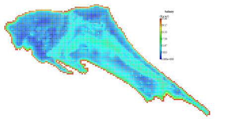
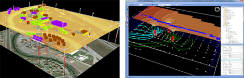
Seer3D is an application for the visualization of field measurement data and the groundwater model results. It includes powerful tools for displaying vector and raster maps, presenting wells, boreholes, lithological, and geophysical data. Showcase your work by merging maps, field data and model results into stunning beautiful 3D scenes! Use the intuitive display control tools to emphasize displayed objects by adjusting their transparency and display types between mesh and solid, cropping objects with on-screen crop tools, and adding annotation, logo, and legend. Create animation videos of plume development, water level changes, flow vector field, and flow paths based on measurement data and model results. Advanced View feature enables you to store arbitrary view points and navigate between them. Present your models with eye-popping 3D stereoscoping display using Quad buffered stereo technology and deliver your Seer3D models with the free Seer3D viewer to your clients for great impression.
|