|
| RockWorks - software in the oil and gas industry |
 |
| RockWorks includes many software tools for the oil and gas industry. From creating cross sections and isopach maps all the way to reservoir modeling, RockWorks2006 gives you the tools to get the job done. |
| |
| RockWorks features applicable to the oil and gas industry |
- The Borehole Manager allows you to import easily all of your reservoir data, storing lithology, elog, stratigraphic, and other downhole data in well files.
|
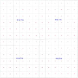
Jeffersonian land grid map depicting sections and townships |
|
- RockWorks2006 contains an LAS file importer with easy selection of curves to import.
|
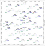
Point map showing well locations and UTM coordinates |
|
- The enhanced stratigraphy picker allows you to display digital or raster elogs (along with any other available log data) and pick stratigraphic tops and bases. As contacts are selected, the correlation panels are drawn on the screen, making pinchouts easier to detect and corrections easier to make.
|
The stratigraphy picker |
|
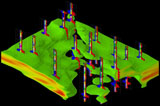
- Display deviated logs in 2D sections and in the RockWorks interactive 3D display.
|
Deviated drillholes in a 2D projected section |
|
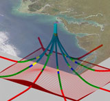
Deviated drillholes in 3D |
|
 |
|
 |
|
- Include rasterlogs in 2D and 3D logs. The interactive depth registration window makes it a snap to define the image's top and base depths.
|
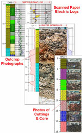
Include raster images in your logs |
|
- Create 2D and 3D contour maps of stratigraphic surfaces and reservoir isopachs. A variety of gridding methods are available.
|
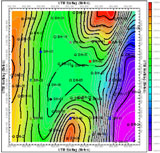
Borehole symbols and color-coded elevation contours |
|
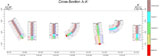
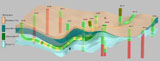
- Create stratigraphic cross sections.
|
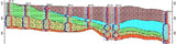
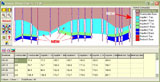
Stratigraphic profile with superimposed gamma/resistivity logs |
|
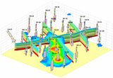
- Display a stratigraphic model in 3D with logs.
|
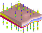
Stratigraphic block model & geophysical logs show as proportional discs |
|
- Use your log data to create solid models of reservoir attributes, with automatic volumetric calculations for each unit.
|
Elogs and resistivity model |
|
Porosity model with elogs and stratigraphic fence in background |
|
- Easily import LogPlot data.
|
 |
|
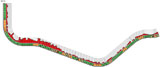
- Create production maps, lease maps, and a variety of reference maps. Float or drape these over your 3D logs, solids, and surfaces.
|
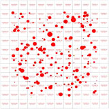
"Bubble" map (aka "Proportional Symbol Map") depicting oil-well production |
|
- Use RockPlot3D to create stunning composite images.
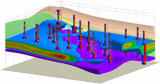
|
Composite hydrocarbon reservoir voxel model (blue with red core), vertical, inclined, and deviated elogs, and stratigraphic fence diagram |
| |
|


