|
| Strater - Log Types |
 |
| |
| Strater includes 12 popular log types to graphically display your data: zone bar, bar, percentage, graphic, well construction, lithology, post, classed post, complex text, line/symbol, crossplot, and depth logs. Strater logs give you full control over all log parameters. You can accept the Strater defaults to automatically create a log, or select a log and easily customize the log features in the Property Inspector. |
| |
Zone Bar Log
Display a wide variety of logging data with the zone bar log. For instance, zone bars can represent sample intervals, alteration zones, contamination layers, etc. They also provide a mechanism to display simple keyword text objects either with or without background fill. |
Create zone bars to display interval information, such as formation thicknesses and alteration zones |
|
Bar Log
Show your data as either a standard bar log or a polarity bar log! A standard bar plots a bar from the data minimum value to the row's data value. The polarity bar plots data based upon zero, so if there is a mix of negative and positive data, bars exist on both sides of the zero line. Effortlessly switch the bar type for bar logs between standard and polarity. |
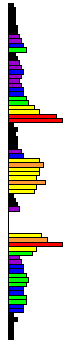
Plot your data using a bar log! |
|
Percentage Log
Visually compare the percentages of items in a borehole easily using the percentage log! The percentage log can be used to show different percentages of alteration types, mineralization types, geochemical data, or rock types. The percentage log uses data fields to create a series of blocks (interval data) or polygons (depth data). You can select any number of numerical fields from a specified table. If you select five fields, five different blocks or polygons are created. The data for each row are normalized to 100 percent, so the data in each row's field can be any value. |
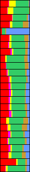
Show the percentage of multiple components per sampling interval using the percentage log! |
|
|
Graphic Log
Create graphic logs that display images directly on the log. The graphic log allows you to specify bitmap file names and show the bitmaps at specified intervals. This is useful in displaying photos of the core, alteration, rock types, sample intervals, etc. |
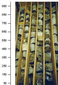 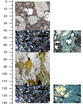
Display bitmap images as a log. Graphic logs are great for showing images versus depth, such as core or thin section photos. |
|
Well Construction Log
The well construction log replicates a well construction diagram for the log, and is generally used in the environmental industry. The well construction log shows how the monitoring well or piezometer was created. This log shows items such as screen, packing material, end caps, and covers. The well construction log is a visual representation of the well rather than a detailed engineering drawing to scale. |

Well construction logs display diagrams of wells |
|
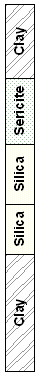
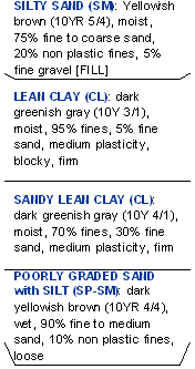
Lithology Log
Show the various stratigraphic layers in the borehole using the lithology log. The display can be as simple as a filled block, or the display can be more elaborate and show weathering patterns and contact line styles. Lithology logs can show distinct contact line styles and indent percentages/scales to show weathering profiles. |
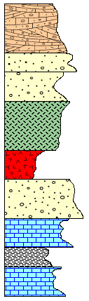
Use the lithology log type to display all your lithologic data! |
|
Post Log Post
logs are used to display symbol positions and text at particular depths. The symbols can represent sample locations at depth or intervals, and in the case of monitoring wells, the depth to water, contamination, etc. Symbols can be rotated according to data in the data table. The log also allows placing text at one of five positions relative to the symbol position |
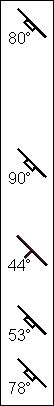
Post symbols at certain depth locations using a post log. You can rotate symbols to any angle specified in the data table. |
|
Classed Post Log
Classed post logs are used to display symbol positions and text at particular depths with symbol properties based on numerical values in the data. Symbols can be rotated according to data in the data table. The log also allows placing text at one of five positions relative to the symbol position. |
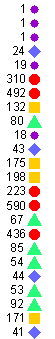
Classed post logs display a symbol at each depth location with the symbol properties based upon another field of data. You can choose to show text labels. |
|
Complex Text Log
Complex text logs can be used to show rock descriptions, alteration descriptions, and any general descriptive text that represents interval data. The text is generally more than just one or two words; it is generally a sentence or series of sentences. The long sentences are wrapped to fit within the bounds specified for the log item. Complex text logs can have arrows, brackets, or offset ticks to separate the text fields. Each text block can be individually edited by double clicking on the text section. |
Display text notes and descriptions easily using the complex text log. You can change the text content or the text properties by simply doubleclicking over the text. |
|
Line/Symbol Logs
Display your depth data as a graph! Line/symbol logs can be useful for displaying assay values, geophysical parameters, moisture content, etc. You can wrap line/symbol logs with multiple styles: truncate, custom wrap, wrap at a 10X scale, or wrap at a 100X scale. |
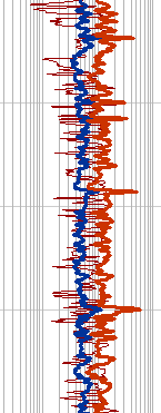
Line/symbol logs show depth data as a graph. |
|
Crossplot Log
See exactly where two curves on a graph intersect using the crossplot log! |
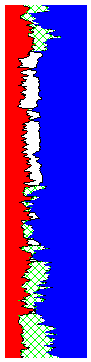
Crossplots plot two line/symbol logs and highlight where they cross each other. You can specify the curve line, fill, and symbol properties for both curves and you can set the fill properties for the overlapping portion. |
|
Depth Logs
Quickly see the depth or elevation of your log using the depth log as a scale bar. Optionally set your depth logs to show depth or elevation, or positive or negative values. You can add tick marks, tick mark labels, and specify the interval between major or minor tick marks. |
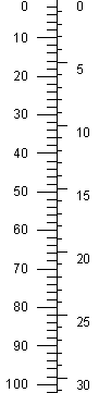
Depth logs provide a depth scale for reference. Depth logs can display depths in feet (above, left), meters (above, right), inches, centimeters, millimeters, or yards. |
| |
|
| |
| |
|
|
|
|
| Helping Communities |
|
Project Review
Ecoseal reviewed the ACIAR Project on Sustainable Agriculture in Saline Environments through Serial Biological Concentration, which was carried out in Pakistan and Australia. |
|
| Read More |
|
Seawater Intrusion Model for the Island of Kayts, Sri Lanka
Assessing sustainable water supply options for Kayts to limit the impact of saline groundwater upconing and saltwater intrusion along the northwest coast of Sri Lanka. |
| Read More |
|
Groundwater Management Model for the Lower Murray, Australia
The aim of this project was to develop a groundwater management model which was used by natural resource managers and the community to better manage the groundwater resources of the Lower Murray. This region has been designated as a potential high-risk aquifer system.
|
| Read More |
|


