|
| Surfer - Contour Maps |
 |
| |
| Surfer 3D Surface Maps The 3D surface map uses shading and color to emphasize your data features. Change the lighting, display angle and tilt with a click of the mouse. Overlay several surface maps to generate informative block diagrams. |
| |
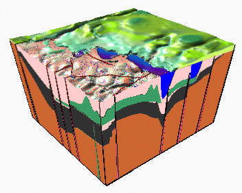 |
| This series of overlaid surface maps illustrates the geology of the Great Lake Ladoga on the margin of the Baltic (Fennoscandian) Shield. |
| |
| 3D Surface Map Features |
- Specify surface color gradation, shininess, base fill and line color
- Control mesh line frequency, color, style, surface offset
- Set lighting horizontal and vertical angles, ambient, diffuse, and specular properties
- Overlay contour maps, image maps, post maps, shaded relief maps, raster and vector base maps, and other surface maps for spectacular presentations
- Choose overlay resample method and resolution, color modulation (blending) of surface and overlays
- Change View tilt, rotation, field of view angles, perspective or orthographic projection
- Set XYZ scales in map units or page length, choose proportional or independent XY scaling
- Use data XY limits or specify a subset of the map
- Control background fill and line color and styles
- Add color scales to explain the data values corresponding to each color
- Disable the display of blanked grid nodes or map the blanked areas to a specific Z level
- Produce a detailed report of the grid statistics
- Substitute a new grid file into an existing map
|
| |
|
|
|
|
| Helping Communities |
|
Project Review
Ecoseal reviewed the ACIAR Project on Sustainable Agriculture in Saline Environments through Serial Biological Concentration, which was carried out in Pakistan and Australia. |
|
| Read More |
|
Seawater Intrusion Model for the Island of Kayts, Sri Lanka
Assessing sustainable water supply options for Kayts to limit the impact of saline groundwater upconing and saltwater intrusion along the northwest coast of Sri Lanka. |
| Read More |
|
Groundwater Management Model for the Lower Murray, Australia
The aim of this project was to develop a groundwater management model which was used by natural resource managers and the community to better manage the groundwater resources of the Lower Murray. This region has been designated as a potential high-risk aquifer system.
|
| Read More |
|


