|
| Surfer - 3D Wireframe Maps |
 |
| |
| Surfer wireframe maps provide an impressive three dimensional display of your data. Use color zones, independent X,Y,Z scaling, orthographic or perspective projections at any tilt or rotation angle, and different combinations of X, Y and Z lines to produce exactly the surface you want. Drape a color-filled contour map over a wireframe map to create the most striking color or black-and-white representations of your data. The possibilities are endless. |
| |
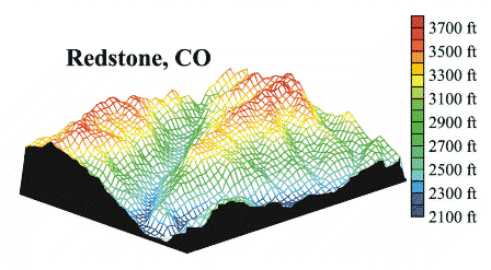 |
| A wireframe map can be used to display any combination of X,Y, and Z lines. A USGS SDTS DEM file was used to create this map and color zones were defined for the X and Y lines. |
| |
| 3D Wireframe Map Features |
- Display any combination of X,Y, and Z lines
- Use automatic or user-defined color zones to highlight different Z levels
- Stack any number of 3D surfaces on a single page
- Optional hidden line removal
- Overlay any combination of contour, filled contour, base, post, and classed post maps on a surface
- Views of the top or bottom of the surface, or both
- Proportional or independent scaling in the X,Y, and Z dimensions
- Full control over axis tick marks and tick labels
- Add a base with optional vertical base lines
- Display the surface at any rotation or tilt angle
|
| |
|
|
|
|
| Helping Communities |
|
Project Review
Ecoseal reviewed the ACIAR Project on Sustainable Agriculture in Saline Environments through Serial Biological Concentration, which was carried out in Pakistan and Australia. |
|
| Read More |
|
Seawater Intrusion Model for the Island of Kayts, Sri Lanka
Assessing sustainable water supply options for Kayts to limit the impact of saline groundwater upconing and saltwater intrusion along the northwest coast of Sri Lanka. |
| Read More |
|
Groundwater Management Model for the Lower Murray, Australia
The aim of this project was to develop a groundwater management model which was used by natural resource managers and the community to better manage the groundwater resources of the Lower Murray. This region has been designated as a potential high-risk aquifer system.
|
| Read More |
|


