|
| Surfer - Base Maps |
 |
| |
| Surfer can import maps in many different formats to display geographic information. You can combine base maps with other maps in map overlays, or can create stand-alone base maps independent of other maps on the page. You can load any number of base maps on a page. Base maps can be imported from DXF, GSI, BLN, SHP, LGO, BNA, GSB, DLG, LGS, MIF, E00, USGS SDTS DLG DDF, EMF, WMF, TIF, PCX, BMP, PLT, CLP, TGA, PCX, JPG, PNG, DCX, WPG, PCT, and other formats. It is easy to overlay a base map on a contour or surface wireframe map, allowing you to display geographic information in combination with the three dimensional data. |
| |
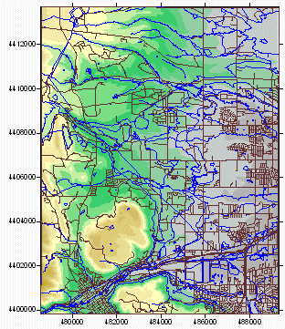
Display your base maps in Surfer alone or overlay them on other maps |
| |
| Base Map Features |
- Create any number of base maps on a single page
- Create independent base maps or overlay base maps on other map types
- Edit line, fill, text, and symbol properties for vector base map formats
- Specify real-world coordinates for TIF, JPG, GIF, and other raster files
- Independent scaling in the X and Y dimensions
- Rotate and tilt base maps to any angle
|
| |
|
|
|
|
| Helping Communities |
|
Project Review
Ecoseal reviewed the ACIAR Project on Sustainable Agriculture in Saline Environments through Serial Biological Concentration, which was carried out in Pakistan and Australia. |
|
| Read More |
|
Seawater Intrusion Model for the Island of Kayts, Sri Lanka
Assessing sustainable water supply options for Kayts to limit the impact of saline groundwater upconing and saltwater intrusion along the northwest coast of Sri Lanka. |
| Read More |
|
Groundwater Management Model for the Lower Murray, Australia
The aim of this project was to develop a groundwater management model which was used by natural resource managers and the community to better manage the groundwater resources of the Lower Murray. This region has been designated as a potential high-risk aquifer system.
|
| Read More |
|


