|
| Surfer - Image Maps |
 |
| |
| Surfer image maps use different colors to represent elevations of a grid file. Create image maps using any grid file format: GRD, DEM, SDTS DDF, GTOP30 HDR. Surfer automatically blends colors between percentage values so you end up with a smooth color gradation over the map. You can add color anchors at any percentage point between 0 and 100. Each anchor point can be assigned a unique color, and the colors are automatically blended between adjacent anchor points. This allows you to create color maps using any combination of colors. Any color fill you choose for an image map can be used with any other image map, even if the associated grid files cover distinctly different Z ranges. Image maps can be created independently of other maps, or can be combined with other maps. They can be scaled, resized, limited and moved. |
| |
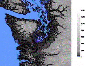
Add color to your image map to customize it. |
| |
| Image Map Features |
- Pixel maps or smoothed images
- Dither bitmaps if needed
- Create an associated color scale
- Create custom color spectrum files for use on any image or shaded relief map
- Overlay image maps with contour, post, or base maps
- Data-independent color spectrum files
- Specify color for missing data
- Change the rotation and tilt angles
|
| |
|
|
|
|
| Helping Communities |
|
Project Review
Ecoseal reviewed the ACIAR Project on Sustainable Agriculture in Saline Environments through Serial Biological Concentration, which was carried out in Pakistan and Australia. |
|
| Read More |
|
Seawater Intrusion Model for the Island of Kayts, Sri Lanka
Assessing sustainable water supply options for Kayts to limit the impact of saline groundwater upconing and saltwater intrusion along the northwest coast of Sri Lanka. |
| Read More |
|
Groundwater Management Model for the Lower Murray, Australia
The aim of this project was to develop a groundwater management model which was used by natural resource managers and the community to better manage the groundwater resources of the Lower Murray. This region has been designated as a potential high-risk aquifer system.
|
| Read More |
|


