|
| Surfer - Map Overlays |
 |
| |
| Map overlays give you a way to combine any number of contour, wireframe, vector, base, and post maps. Draping a filled contour map over a wireframe map produces the most striking display of 3D data possible. And because you can overlay any number of maps, you can show any amount of data on a single map. |
| |
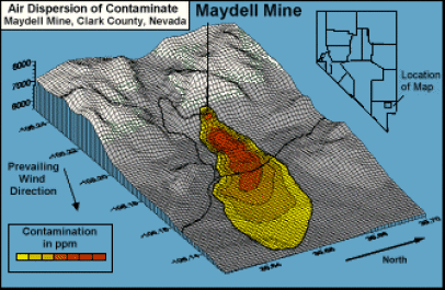
This map was created by overlaying two contour maps, a basemap, and a wireframe map in order to display contaminate spread. |
| |
| |
|
|
|
|
| Helping Communities |
|
Project Review
Ecoseal reviewed the ACIAR Project on Sustainable Agriculture in Saline Environments through Serial Biological Concentration, which was carried out in Pakistan and Australia. |
|
| Read More |
|
Seawater Intrusion Model for the Island of Kayts, Sri Lanka
Assessing sustainable water supply options for Kayts to limit the impact of saline groundwater upconing and saltwater intrusion along the northwest coast of Sri Lanka. |
| Read More |
|
Groundwater Management Model for the Lower Murray, Australia
The aim of this project was to develop a groundwater management model which was used by natural resource managers and the community to better manage the groundwater resources of the Lower Murray. This region has been designated as a potential high-risk aquifer system.
|
| Read More |
|


