|
| Surfer - Post Maps |
 |
| |
| Post maps show X,Y locations with fixed size symbols or proportionally scaled symbols of any color. Create post maps independent of other maps on the page, or overlay the posted points on a base, contour, vector, or surface map. For each posted point, specify the symbol and label type, size, and angle. Also create classed post maps that identify different ranges of data by automatically assigning a different symbol or color to each data range. Post your original data point locations on a contour map to show the distribution of data points on the map, and to demonstrate the accuracy of the gridding methods you use. |
| |
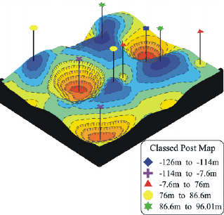
Different symbols are used to display different ranges of data in classed post maps. Here, a classed post map is overlaid on a wireframe map and 3D label lines have been added to lift the symbols up off the map surface.
Use post maps to display the location of your XY data. |
| |
| Post Map Features |
- Create any number of post maps on a single page
- Post from any number of files
- Use proportional or fixed size symbols
- Full control of symbol style, color, and frequency
- Post data on contour, vector, surface, or base maps
- Post every point or every nth point
- Rotate and tilt post maps to any angle
- Make a Classed Post Map to post different symbols for specified ranges of data values
- Create a classed post legend to display the symbols and data ranges
- Specify custom symbols from the worksheet
- Add labels from a data file and adjust the angle of the label and the plane in which the label appears
- Change data files without resetting post map and classed post map parameters
|
| |
|
|
|
|
| Helping Communities |
|
Project Review
Ecoseal reviewed the ACIAR Project on Sustainable Agriculture in Saline Environments through Serial Biological Concentration, which was carried out in Pakistan and Australia. |
|
| Read More |
|
Seawater Intrusion Model for the Island of Kayts, Sri Lanka
Assessing sustainable water supply options for Kayts to limit the impact of saline groundwater upconing and saltwater intrusion along the northwest coast of Sri Lanka. |
| Read More |
|
Groundwater Management Model for the Lower Murray, Australia
The aim of this project was to develop a groundwater management model which was used by natural resource managers and the community to better manage the groundwater resources of the Lower Murray. This region has been designated as a potential high-risk aquifer system.
|
| Read More |
|


