|
| Surfer - Contour Maps |
 |
| |
| Surfer contour maps give you full control over all map parameters. You can accept the Surfer intelligent defaults to automatically create a contour map, or double-click a map to easily customize map features. |
| |
| Display contour maps over any contour range and contour interval, or specify only the contour levels you want to display on the map. And with Surfer you can add color fill between contours to produce dazzling displays of your maps, or produce gray scale fills for dramatic black and white printouts. |
| |
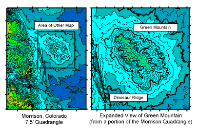 |
| A USGS DEM of the Morrison, CO Quadrangle was used to create the above contour map. The right half is an enlarged portion of the DEM. |
| |
| Contour Map Features |
- Automatic or user-defined contour intervals and ranges
- Full control over contour label format, font, frequency, placement, and spacing
- Drag contour labels to place them exactly where you want them
- Automatic or user-defined color for contour lines
- Color fill between contours, either user-specified or as an automatic spectrum of your choice
- Save and retrieve custom line styles and fills for contour maps
- Full control over hachures
- Regulate smoothing of contour lines
- Reshape contour lines
- Blank contour lines in areas where you don't want to show any data
- Specify color for blanked region
- Rotate and tilt contour maps to any angle
- Add color scale or distance scale bars
- Independently scale in the X and Y dimensions
- Full control over axis tick labels, tick spacing, grid lines and titles
- Create any number of contour maps on a page
- Print maps in black-and-white or full color
- Overlay base, vector, shaded relief, image, or post maps on contour maps
- Drape contour maps over 3D surfaces for dramatic displays
- Export contours in 3D DXF format
|
| |
|
|
|
|
| Helping Communities |
|
Project Review
Ecoseal reviewed the ACIAR Project on Sustainable Agriculture in Saline Environments through Serial Biological Concentration, which was carried out in Pakistan and Australia. |
|
| Read More |
|
Seawater Intrusion Model for the Island of Kayts, Sri Lanka
Assessing sustainable water supply options for Kayts to limit the impact of saline groundwater upconing and saltwater intrusion along the northwest coast of Sri Lanka. |
| Read More |
|
Groundwater Management Model for the Lower Murray, Australia
The aim of this project was to develop a groundwater management model which was used by natural resource managers and the community to better manage the groundwater resources of the Lower Murray. This region has been designated as a potential high-risk aquifer system.
|
| Read More |
|


