|
| Surfer - Vector Maps |
 |
| |
| Instantly create vector maps in Surfer to show direction and magnitude of data at points on a map. You can create vector maps from information in one grid or two separate grids. The two components of the vector map, direction and magnitude, are automatically generated from a single grid by computing the gradient of the represented surface. At any given grid node, the direction of the arrow points in the direction of the steepest descent. The magnitude of the arrow changes depending on the steepness of the descent. Two-grid vector maps use two separate grid files to determine the vector direction and magnitude. The grids can contain Cartesian or polar data. With Cartesian data, one grid consists of X component data and the other grid consists of Y component data. With polar data, one grid consists of angle information and the other grid contains length information. Overlay vector maps on contour or wireframe maps to enhance the presentation! |
| |
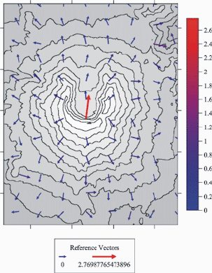
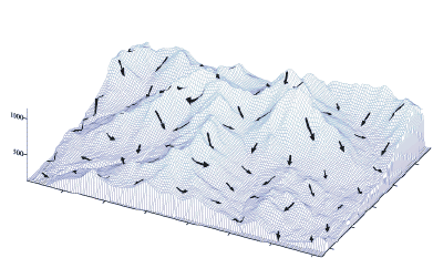
A vector map of Mt. St. Helens overlaid on a contour map. Use a color scale bar or legend to indicate the magnitude of the arrows. |
| |
| Vector Map Features |
- Define arrow style, color, and frequency
- Symbol color may be fixed or based on vector magnitude
- Display map scales, color scale bars, and vector scale legends
- Scale the arrow shaft length, head length, and width
- Control vector symbol origin
- Choose from linear, logarithmic, or square root scaling methods
|
| |
|
|
|
|
| Helping Communities |
|
Project Review
Ecoseal reviewed the ACIAR Project on Sustainable Agriculture in Saline Environments through Serial Biological Concentration, which was carried out in Pakistan and Australia. |
|
| Read More |
|
Seawater Intrusion Model for the Island of Kayts, Sri Lanka
Assessing sustainable water supply options for Kayts to limit the impact of saline groundwater upconing and saltwater intrusion along the northwest coast of Sri Lanka. |
| Read More |
|
Groundwater Management Model for the Lower Murray, Australia
The aim of this project was to develop a groundwater management model which was used by natural resource managers and the community to better manage the groundwater resources of the Lower Murray. This region has been designated as a potential high-risk aquifer system.
|
| Read More |
|


