|
| TEMP/W - Thremal analysis. |
 |
Comprehensive and Powerful
TEMP/W is a finite element software product for analyzing thermal changes in the ground due to environmental changes or due to the construction of facilities such as buildings or pipelines. The comprehensive formulation makes it possible to analyze both simple and highly complex geothermal problems. You can apply TEMP/W to the geothermal analysis and design of geotechnical, civil, and mining engineering projects, including facilities that are subjected to freezing and thawing temperature changes.
TEMP/W is formulated to account for the latent heat associated with water turning into ice and ice turning into water. The rate at which the latent heat is absorbed or released is controlled by an unfrozen water content function. Above the phase change temperature, all the water is unfrozen. As the temperature falls below the phase change point, the portion of the water that remains unfrozen decreases. Complete flexibility in defining the unfrozen water content function makes it possible to analyze a wide variety of ground conditions. When linked with SEEP/W or AIR/W it can consider convective heat transfer if flowing water or moving air. Easy to Use
|
Defining a Geothermal Model
|
The unique CAD-like technology in TEMP/W allows you to generate your finite element mesh by drawing regions on the screen. You can then specify material properties and interactively apply boundary conditions. Boundary conditions can be automatically created from imported climate data, thermosyphon properties, and convective surface data. If you make a mistake, you can correct it using the Undo command.
|
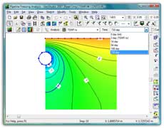
Viewing the Analysis Results
|
Once you have solved your geothermal problem, TEMP/W offers many tools for viewing results. Generate contours or x-y plots of any computed parameter, such as temperature, flux, gradient, latent heat, or net radiation. Gradient vectors show the energy flow direction and rate. Transient conditions can be shown by plotting the changing frost front position over time. View energy flow paths and flux quantities. Interactively query computed values by clicking on any node, element Gauss region, or flux section. Then export the results into other applications, such as Microsoft Excel or Word, for further analysis or to prepare presentations.
|
Typical Applications
TEMP/W can model almost any geothermal problem, including:
|
Degradation of permafrost beneath warm buildings or around a warm, buried pipeline
Development of a frost bulb around a chilled pipeline
Ground freezing for soil stabilization, including use of freezing pipes around mine shafts or thermosyphons on top of earth dams
Freeze-thaw action beneath roadways and airport runways
Frost depth penetration beneath chilled structures such as a recreational ice surface or a highway during winter
Effectiveness of various insulation alternatives for reducing freezing and/or thawing
|
| Formulation |
TEMP/W is formulated to analyze ground temperature changes, including the effects of latent heat due to the phase change from ice to water and from water to ice. The analysis of latent heat effects makes TEMP/W a powerful software product for analyzing various ground conditions. TEMP/W uses Gaussian numerical integration to formulate the element characteristic matrices. The integration involves sampling the element characteristics at selected points and summing the sampled values. As a result, it is possible to use a different material property at each sampled point, allowing the material properties to vary throughout the element.
The thermal conductivity of the soil varies with temperature. TEMP/W accommodates this with a general conductivity function, making it possible to consider a smooth transition in conductivity as the temperature changes from thawed to frozen conditions and vice versa.
|
| Features: |
- Analysis types include steady-state or transient energy flow, 2-D energy flow in a cross-section or in plan view, and 3D axisymmetric energy flow.
- Boundary condition types include temperature or flux (fixed or a function of time), thermosyphons, convective surfaces, or imported climate data.
|
- Latent heat modeled using an unfrozen water content function.
- Frozen and unfrozen volumetric heat capacity and the volumetric water content specified individually for each soil type.
|
- Adaptive time stepping automatically inserts additional time steps when nodal temperatures change more than the specified criteria.
- Initial conditions obtained from a previous analysis or specified as constant nodal temperatures.
|
|
| |
Measured climate data can be pasted from a spreadsheet into TEMP/W and used to determine the actual ground surface temperatures with or without snowpack. TEMP/W will use precipitation data to accumulate snow depths over the winter. An energy balance approach is used to calculate ground temperatures beneath snow and to melt snow during the spring. Link it with SEEP/W or AIR/W for convective heat transfer analysis.
|
Using finite-element computed pore-water pressures in SLOPE/W makes it possible to deal with highly irregular saturated/unsaturated conditions or transient pore-water pressure conditions in a stability analysis. For example, you can analyze changes in stability as the pore-water pressure changes with time.
|
Engineering Methodology Book |
|
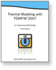
When you purchase a TEMP/W 2007 license you also receive a copy of the TEMP/W Engineering Methodology book, Thermal Modeling with TEMP/W 2007. This book is not a software manual but a full-length book that discusses why and how to model. It does not describe how to use the commands in the software or which buttons to click - that is provided in detail in the Online Help. Instead it is about thinking: how to think before, during and after setting up and solving a model. The Engineering Methodology book has chapters devoted to: |
| Numerical Modeling: What, Why and How
Geometry and Meshing
Material Models and Properties
Bounday Conditions
Analysis Types
Functions in GeoStudio
Numerical Issues
Visualization of Results
Modeling Tips and Tricks
Illustrative Examples
Theory |
| |
|