|
| VADOSE/W - Vadose zone and oil cover analysis. |
 |
Environmental Impact on Soil Conditions
Understanding unsaturated soil mechanics is now critical for geotechnical engineers performing slope stability analyses, designing soil covers for mine or municipal waste facilities, or determining the effect of agricultural or irrigation projects on groundwater flow. Environmental conditions at the ground surface, such as precipitation, evaporation and transpiration, have been increasingly recognized as having a significant impact on soil behaviour in the unsaturated or vadose zone. In fact, "unsaturated soil mechanics may have more to do with the ground surface moisture flux conditions than it has to do with the thickness of the unsaturated soil zone" (D.G. Fredlund, Geotechnical News, Dec. 2001).
So how can you determine the impact of environmental conditions on the unsaturated zone? VADOSE/W provides a solution to this problem.
Comprehensive and Powerful
VADOSE/W is a finite element software product for analyzing flow from the environment, across the ground
surface, through the unsaturated vadose zone and into the local groundwater regime. Its comprehensive formulation allows you to analyze both simple and complex problems. For example, you can perform a simple analysis of ground infiltration due to rainfall, or you can build a sophisticated model that considers snow melt and root transpiration, as well as surface evaporation, runoff, ponding, and gas diffusion. You can apply VADOSE/W to the analysis and design of geotechnical, mining, hydrogeological, agricultural, and civil engineering projects. Easy to Use
|
A Complete Modeling Solution
|
VADOSE/W's unique CAD-like interface allows you to generate your finite element mesh by drawing regions on the screen, then interactively apply boundary conditions and specify material properties. You can even estimate the material property functions from easily measured parameters like grain-size, saturated conductivity, saturated water content, and the air-entry value. If you make a mistake, you can correct it using the Undo command.
To create a VADOSE/W model:
Define geometry graphically with the mouse or by typing in values. Generate your finite element mesh and then add a soil cover mesh at the surface.
Specify material properties and climate data by pasting directly from a spreadsheet, importing from the included databases, or by typing in your own values.
Interactively apply boundary conditions as fully coupled to the climate, as a function of time, or as specific values for temperature, head, pressure, total or unit water flux, or a potential seepage surface.
Scale data automatically in order to conduct sensitivity studies or to create data suited to your specific site.
Define initial conditions for the analysis by drawing an initial water table and nodal temperatures or by using computed results from a previously solved problem.
Comprehensive Results
|
Viewing the Analysis Results
|
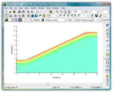
Once you have solved your evaporative flux problem, VADOSE/W offers many tools for viewing results. Generate contours or x-y plots of any computed parameter for any time steps. Velocity vectors show flow direction and rate. Transient conditions can be shown as the changing water table position over time. Interactively query computed values by clicking on any node, Gauss region, or flux section.
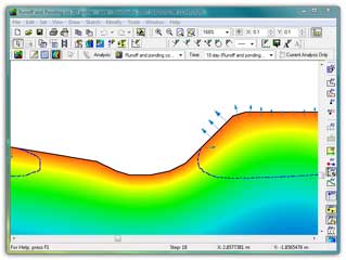
Infiltration and ponding resulting from high rainfall event
Computed Parameters
When VADOSE/W analyzes an evaporative flux problem, it computes data regarding:
Precipitation and infiltration
Snow accumulation and melt
Plant transpiration
Ground freezing and thawing
Potential and actual evaporation
Surface seepage, runoff and ponding
Groundwater recharge
|
| Specific computed parameters include: |
| Temperature
Total Head
Pressure
Pressure Head
Boundary Flux
Liquid Velocity
Vapor Velocity
Ice Content
Water Content
Vapor Pressure
Conductivity
Gas Concentration / Flux |
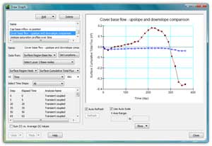
Comparison of upslope and downslope cover
base flow on a shallow sloped cover. |
Soil surface results data includes (for each time interval, or cumulative since Day 1): |
Precipitation
Net Radiation
Potential Evaporation
Actual Evaporation
Runoff
Infiltration
Snow Depth
Actual Transpiration
Water Balance data includes cumulative:
Precipitation
Runoff
Boundary Fluxes
Evaporation
Storage
Water Balance
Plant Transpiration
Cover layer interface results data includes:
Volume of liquid flow
Volume of vapor flow
Total volume across layer
Total gas mass across layer
|
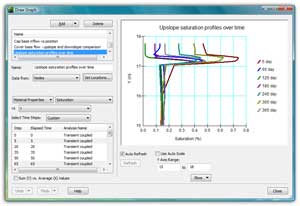
Upslope saturation profiles during a 365 day
simulation in a shallow sloped cover. |
| Formulation |
Computing the Surface Flux Boundary
The key to modeling the vadose zone is predicting an accurate surface boundary condition. VADOSE/W computes this surface flux boundary by coupling ground heat, mass and vapor flow with actual climate data.
VADOSE/W extends the concepts found in the popular SoilCover program into two dimensions. Critical to the formulation of VADOSE/W is its ability to predict actual evaporation as a function of the soil water stress state, rather than simply using soil water content, drying time, or empirical user-defined relationships. Instead, VADOSE/W uses the rigorous Penman-Wilson method to compute actual evaporation as a function of soil water pressure, a stress state variable. It is the only 2D product using this state-of-the-art approach.
Actual and Potential Evaporation
Actual Evaporation (AE) is only equal to Potential Evaporation (PE) when the soil is saturated. If the soil at the ground surface is not saturated, the AE rate can be much less than the PE rate. Wilson (1990, 1994) showed that the only way AE can be predicted correctly for all soil types and climatic conditions is to base the calculation on both the negative pore-water pressures and temperatures in the ground. Wilson modified the Penman (1948) method to make the actual evaporation rate dependent on the relative humidity of the soil and the air. The relative humidity in the soil can only be known if the soil temperature and water pressure are known and solved for simultaneously. To solve this complex set of equations, it is necessary to include vapor flow in the soil. VADOSE/W meets all these requirements, and is fully coupled in two dimensions.
Gas Transport
VADOSE/W is formulated to analyze transient 2-dimensional oxygen or radon gas diffusion, dissolution and decay in response to changing heat and moisture conditions in the ground. The gas transport analysis is carried out simultaneously with the coupled heat and mass transfer solution. This feature can be used to determine gas concentrations and mass flows into or out of the ground in response to pre-set or user input concentration boundary conditions.
|
| Features: |
- Generate soil cover meshes based on cover thickness and soil type data.
- Model complex soil cover stratigraphy, including pinchout layers.
- Use adaptive time stepping during the solve process to help with convergence and the diurnal nature of climate boundary data.
- Estimate soil properties based on grain size data or other input soil functions.
|
- Use a scalable global climate database or enter site specific climate data.
- Specify net solar radiation or potential evaporation as your climate data, or let VADOSE/W estimate the energy component.
- Import and export DXF, WMF, EMF, or bitmap graphics.
- Density-dependent analysis with contaminant density different than groundwater density.
- And many more!
|
|
| |
Use VADOSE/W pore-water pressures in SLOPE/W
|

Site-measured net solar radiation data can be imported if
available; otherwise, VADOSE/W uses other climate
data
to predict similar values for net solar radiation.
Engineering Methodology Book
When you purchase a VADOSE/W 2007 license you also receive a copy of the VADOSE/W Engineering Methodology book, Vadose Zone Modeling with VADOSE/W 2007. This book is not a software manual but a full-length book that discusses why and how to model. It does not describe how to use the commands in the software or which buttons to click - that is provided in detail in the Online Help. Instead it is about thinking: how to think before, during and after setting up and solving a model. The Engineering Methodology book has chapters devoted to: |
| Numerical Modeling: What, Why and How
Geometry and Meshing
Material Properties
Bounday Conditions
Analysis Types
Functions in GeoStudio
Numerical Issues
Visualization of Results
Modeling Tips and Tricks
Illustrative Examples
Theory |
| |
|
|
|
|
| Helping Communities |
|
Project Review
Ecoseal reviewed the ACIAR Project on Sustainable Agriculture in Saline Environments through Serial Biological Concentration, which was carried out in Pakistan and Australia. |
|
| Read More |
|
Seawater Intrusion Model for the Island of Kayts, Sri Lanka
Assessing sustainable water supply options for Kayts to limit the impact of saline groundwater upconing and saltwater intrusion along the northwest coast of Sri Lanka. |
| Read More |
|
Groundwater Management Model for the Lower Murray, Australia
The aim of this project was to develop a groundwater management model which was used by natural resource managers and the community to better manage the groundwater resources of the Lower Murray. This region has been designated as a potential high-risk aquifer system.
|
| Read More |
|