|
| LogPlot 7 - the standard in log plotting software |
 |
| |
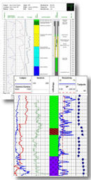
LogPlot software has been used by geoscientists since 1983 to display their geotechnical, environmental, geophysical, mud/gas, and mining data as a graphic boring log.
Compile the data into the design at any vertical scale for single-page, multi-page, or continuous logs. Distribute the free LogView program with your logs so your clients can view and print you logs. Or, create HTML log pages or JPG, BMP, TIFF, PNG, WMF and EMF images. |
 |
|
|
| |
| The LogPlot Log Designer |
| LogPlot offers almost unlimited flexibility for log layout via its easy-to-use, built-in Log Designer. With a revamped point-and-click interface, LogPlot's Log Designer makes it easy to customize logs for different clients and projects. |
| |
| The LogPlot Data Editor |
| Field data can be entered into LogPlot's Data Editor using the keyboard, copy/paste, data collection, and/or import tools (LAS, RockWorks, Excel, ASCII, DBF). Multiple libraries of soil and rock types are included with LogPlot, and you can easily customize them to suit your company's needs. |
| |
| Related Products |
| RockWorks: Project-wide management and interpolation of borehole data, with mapping, cross sections, fence diagrams, solid models, and much more. Shares data with LogPlot. |
| |
| RockWorks Utilities: A subset of the RockWorks program. Includes gridding, contouring, solid modeling, and general tools. (Does not include the borehole database manager.) |
| |
| RockWare GIS Link: Import your RockWorks borehole locations into ArcMap, and generate cross-sections & profiles, fence diagrams, logs, and structural & isopach contours using ArcMap and RockWorks. |
| |
| |
|
|
|
|
| Helping Communities |
|
Project Review
Ecoseal reviewed the ACIAR Project on Sustainable Agriculture in Saline Environments through Serial Biological Concentration, which was carried out in Pakistan and Australia. |
|
| Read More |
|
Seawater Intrusion Model for the Island of Kayts, Sri Lanka
Assessing sustainable water supply options for Kayts to limit the impact of saline groundwater upconing and saltwater intrusion along the northwest coast of Sri Lanka. |
| Read More |
|
Groundwater Management Model for the Lower Murray, Australia
The aim of this project was to develop a groundwater management model which was used by natural resource managers and the community to better manage the groundwater resources of the Lower Murray. This region has been designated as a potential high-risk aquifer system.
|
| Read More |
|


