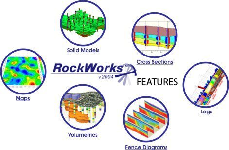
RockWorks has long been the
standard in the petroleum, environmental, geotechnical and mining industry
for subsurface data visualization because of popular tools such
as maps, logs, cross sections, fence diagrams, solid models and
volumetrics.
RockWorks gives you numerous
options for analyzing your subsurface data, and accepts many different
data types, such as stratigraphy, lithology, downhole data, fracture data
and hydrology and aquifer data .
In addition to it's already
impressive collection of existing capabilities, the latest RockWorks
version has numerous new features.
 NEW FEATURES IN ROCKWORKS
2004 NEW FEATURES IN ROCKWORKS
2004
| RockWorks in Industry |
Other Features |
|
Data
types:
- Lithology data
- Stratigraphy data
- Downhole data
(geophysical, geochemical and geotechnical)
- Fracture data
- Hydrology and
aquifer data
Other geology tools:
- 3D objects
- Grid model tools
- More solid model
tools
- Stereonets, rose
diagrams and other structural geology tools
- Piper diagrams,
Stiff plots and other hydrochemistry/hydrology tools
- Ternary diagrams and
other statistics tools
- Geotechnical
- Miscellaneous
geology tools
Program details:
- Page layout
(ReportWorks)
- 3D viewing
(RockPlot3D)
- RockWorks Command
Language (RCL)
- Import/export
features
- System requirements
- Help and tutorials
|
|